★Hiking Map Book販売/トレイルマップ無料配布終了のお知らせ (New hiking map books on sale/End of free map distribution)
2019年6月、みちのく潮風トレイルは全線開通しました。
これまでの間、本当に多くの方にトレイルを歩いていただきましたこと、心より御礼申し上げます。
「みちのく潮風トレイル Hiking Map Book」は、みちのく潮風トレイル全線を歩いたハイカーの皆様に監修・作成していただいた手作りのものです。
地点間の距離や標高差、道の分岐や進行方向などの歩くことに必要な情報を掲載しております。歩くための計画は立てやすくなっていると思います。
一方で、見所や観光施設などのガイドブック要素は、地図の見やすさを優先して省略しておりますが、来年度以降、地元の皆様のご意見も伺いながら、地域の見所や観光施設、これまで掲載できなかった民間の宿泊施設、飲食店やお店の情報などを掲載したガイドブックの作成・発売も予定しており、これらと併用していただくことで、みちのく潮風トレイルをより楽しんで歩いていただければと思っております。
これまでのように無料での配布ではなくなり、申し訳ないのですが、マップの販売で得た収益は、1,000キロを超える長い長いみちのく潮風トレイルを、未来に向けて「持続可能な歩き続けることのできる道」にし続けていくための、人件費や、整備活動、地域やハイカーの皆さんに楽しんで歩いていただくための活動等の費用として活用してまいりますので、ご理解いただけますと幸いです。
皆さまには、ご理解ご協力のほど、何卒よろしくお願いいたします。これからも、変わらずみちのく潮風トレイルを応援していただければ幸いです。
■Hiking Map Book販売概要■
販売開始日:2020年10月1日(木)
販売場所:
みちのく潮風トレイル 名取トレイルセンター(宮城県名取市)
その他の販売場所は、こちら。
価格:1部 1,500円(税抜)/1,650円(税込)
10部セット 13,500円(税抜)/14,850円(税込)
区間:
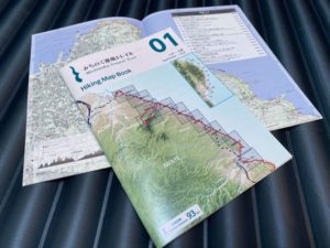
Book 01 八戸〜久慈 ( 蕪島〜久慈駅)区間距離93km
Book 02 久慈〜宮古(北部 ) (久慈駅〜摂待駅)区間距離99km
Book 03 宮古(北部)〜山田 (摂待駅~陸中山田駅)区間距離106km
Book 04 山田〜釜石 (陸中山田駅~釜石駅)区間距離121km
Book 05 釜石〜陸前高田 (釜石駅~陸前高田駅)区間距離129km
Book 06 陸前高田〜気仙沼(南部) (陸前高田駅~本吉駅)区間距離102km
Book 07 気仙沼(南部)〜女川 (本吉駅~女川駅)区間距離114km
Book 08 女川〜石巻 (女川駅~石巻駅)区間距離102km
Book 09 石巻〜名取 (石巻駅~名取トレイルセンター)区間距離82km
Book 10 名取〜相馬 (名取トレイルセンター~松川浦)区間距離97km
The Michinoku Coastal Trail fully opened in June 2019, after years of sections opening one by one, starting with the trail from Kabushima, Hachinohe in Aomori Prefecture to Kosode, Kuji, in Iwate Prefecture on November 29th, 2013.
We are working day by day to maintain and promote use of the Michinoku Coastal Trail because we believe that hikers coming to visit Tohoku will help this area recover and grow.
We want to thank the many hikers who have already come to visit from the bottom of our heart.
We have been distributing trail maps made by the Ministry of the Environment to hikers. These maps were made when that particular section of the trail was completed. In total, about 70,000 of these maps have been distributed to hikers.
Meanwhile, March 11th of next year (2021) will mark ten years since the 2011 tsunami, and the national government’s 10 year intensive reconstruction period will end. The Michinoku Coastal Trail, which started as a national project to support recovery, will also enter a new stage of sustainable management, relying not only on the national government but working with civil recovery projects and regional planning.
This is why we have made new Michinoku Coastal Trail Hiking Map Books, which we started selling on October 1st, 2020. These new map books will replace the Ministry of the Environment trail maps. The map books were produced by Michinoku Trail Club (our organization), which serves as the headquarters of the MCT, and were 100% made with private, non-governmental funds.
We will continue to distribute the remaining Ministry of the Environment trail maps for free until March 31st, 2021.
※Note: We have finished distributing the free maps as of March 31st, 2021.
The new hiking map books were made and edited by hikers who have walked the entire trail. The new maps show information hikers need: distances between points on the trail, elevation changes, places to make turns and directional information. We think these maps will really help hikers plan their hikes.
The map books are in both Japanese and English, with the exception of detailed markings (area names, etc.) on the map.
You’ll notice that information usually found in guidebooks, like points of interest and tourist attractions, are omitted so the maps are easier to read. We’re planning to publish a guidebook next fiscal year or later while consulting with local people. The guidebook will introduce those points of interest, tourist attractions, and information about private businesses that we weren’t able to list before like lodging facilities, restaurants and stores. With the map books and the upcoming guidebook, you’ll be able to enjoy your hike even more.
We are very sorry that we are not able to continue to distribute free maps. The profits from selling these maps will be used for the work needed to sustainably manage this 1000 km-long trail, so it will continue to be walkable into the future: personnel expenses, maintenance work, and other activities that will make hiking even more enjoyable for local people and hikers.
We would love for you to buy these Michinoku Coastal Trail Hiking Map Books, our new creations, and we would also really appreciate your opinion on how we can improve these maps even further.
We thank you from the bottom of our hearts for your support and understanding.
■About the Hiking Map Books
Release date: Hiking Map Books are on sale as of Thursday, October 1st 2020 (Thursday)
Where to buy:
Michinoku Coastal Trail Natori Trail Center
For a list of other places to buy the map books in person, see this page
You can buy the map books online via our new online shop.
Price: 1,500 yen per map (tax not included) / 1,650 yen per map (tax included)
Full set of 10 maps: 13,500 yen (tax not included) / 14,850 yen (tax included)
Sections:
Book 01 Hachinohe to Kuji(Kabushima to Kuji Station) , 93 km
Book 02 Kuji to Miyako(Kuji Station to Settai Station) , 99 km
Book 03 Miyako to Yamada(Settai Station to Rikuchu-Yamada Station) , 106 km
Book 04 Yamada to Kamaishi(Rikuchu-Yamada Station to Kamaishi Station) , 121 km
Book 05 Kamaishi to Rikuzentakata(Kamaishi Station to Rikuzentakata Station) , 129 km
Book 06 Rikuzentakata to Kesennuma(Rikuzentakata Station to Motoyoshi Station) , 102 km
Book 07 Kesennuma to Onagawa(Motoyoshi Station to Onagawa Station) , 114 km
Book 08 Onagawa to Ishinomaki(Onagawa Station to Ishinomaki Station) , 102 km
Book 09 Ishinomaki to Natori(Ishinomaki Station to Natori Trail Center) , 82 km
Book 10 Natori to Soma(Natori Trail Center to Matsukawaura) , 97 km